
Yerrida North
Juggernaut Copper-Gold Targets
The Juggernaut Copper-Gold Targets were identified during a review of legacy lag and soil sampling data completed by Xstrata in the mid to late 2000s. In particular, this review identified a large lead-zinc lag soil anomaly that was not drill tested.
Location of the Diorama, Juggernaut, and Baroo Copper-Gold targets. Note prospective zones of interest in the western (yellow) and eastern (red) portions of the Yerrida Basin. The Ida Fault is shown in blue, with an interpreted basin defining fault shown in purple, with simplified outlines of the Bryah and Yerrida basins also displayed.
Great Western completed considerable additional lag soil sampling west and north of this identified zone of anomalism. The sampling extended the lead-zinc anomaly footprint and, importantly, identified copper anomalism to the north. Two anomalous zones were interpreted to represent one broad and zoned geochemical anomaly.
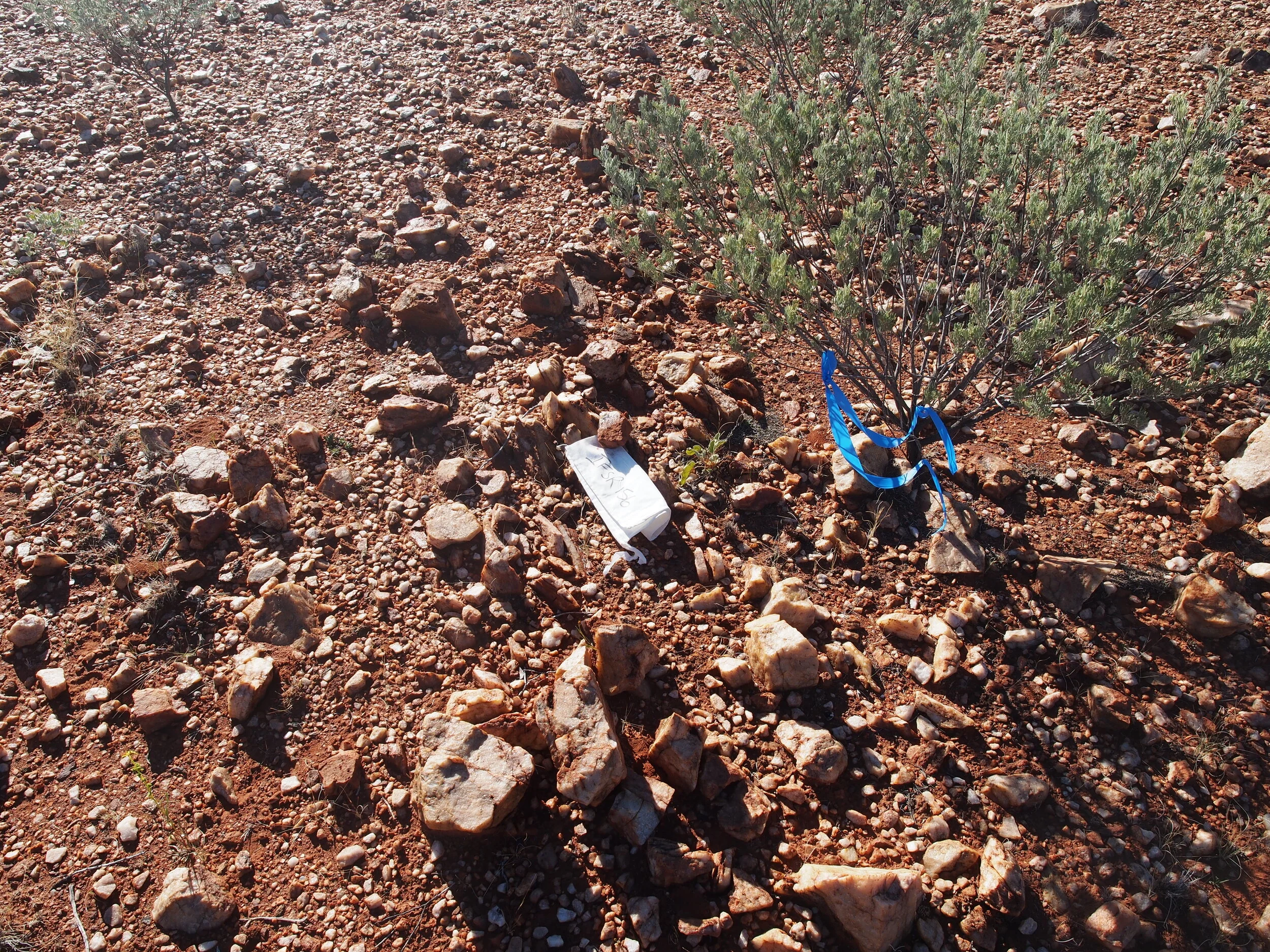
Field mapping and rock-chip sampling was then undertaken to ground truth the soil anomalism, with geological units mapped including sedimentary rocks (siltstones, sandstones, cherts/exhalates) and basaltic volcanic rocks of the Killara Formation. The basaltic units included pillow and pepperite textures, representing sub aqueous deposition. The association between sedimentary and volcanic rocks suggest a deep seafloor geological environment with syngenetic volcanic activity, particularly evident by pillow and pepperite textures within the basaltic units.
The Killara Formation has been determined by previous studies to be the equivalent of the DeGrussa Formation, host to the DeGrussa and Monty copper-gold VHMS Deposits in the adjacent Byrah Basin. The Killara Formation is thought to be of similar age with similar types of sedimentary and volcanic rock units of the DeGrussa Formation.
Rock-chip sampling completed at Juggernaut recorded significant results that included: silver (ranging between 0.24g/t to 20g/t), lead (range: 145ppm – 4,460ppm), zinc (range: 682ppm – 4,850ppm), and copper (range: 427ppm – 850ppm).
Great Western interpreted the zoned lag soil lead-zinc and copper anomalism together with the mapped geological association between sedimentary and volcanic rocks suggests a deep seafloor geological environment, represents a highly prospective VHMS mineralisation system at Juggernaut.
The Company believes the mapped geological units at surface represent a position outboard from a volcanic vent, with potential at depth to define copper mineralisation below a black smoker position of a VHMS system. The association between the mapped fault and interpreted fault structures and lag soil copper anomalism is considered potential leakage of mineralisation at depth.
Further interpretation and modelling of the geological, geochemical, and structural data by Great Western has found Juggernaut represents a potential VHMS copper-gold “camp”, with six separate drill targets defined. VHMS style mineralisation is often formed in clusters of deposits and the Company believes these six individual targets represent this mineralisation characteristic.
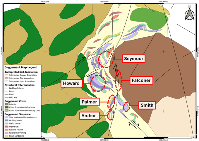
Six VHMS targets have been identified at the Juggernaut Copper-Gold Camp, interpreted to be outboard from the sulphide zone of a VHMS mineralisation system.
Diorama Copper-Gold Target
The Diorama Target is a DeGrussa Style copper-gold target located immediately north of Great Western’s Juggernaut copper-gold targets). This target was initially defined as a lag copper anomaly, with field mapping defining gossanous quartz from the limited surface outcrop at this location, which was mapped in some areas with extents greater than 100m. Shallow cover was defined throughout the target’s area, that could potentially obscure copper mineralisation just below surface.
The gossanous quartz potentially represents highly weathered sulphides, which may be significant developed below surface and potential host to copper-gold mineralisation. The gossans were noted to be interbedded with siltstone and shale units.
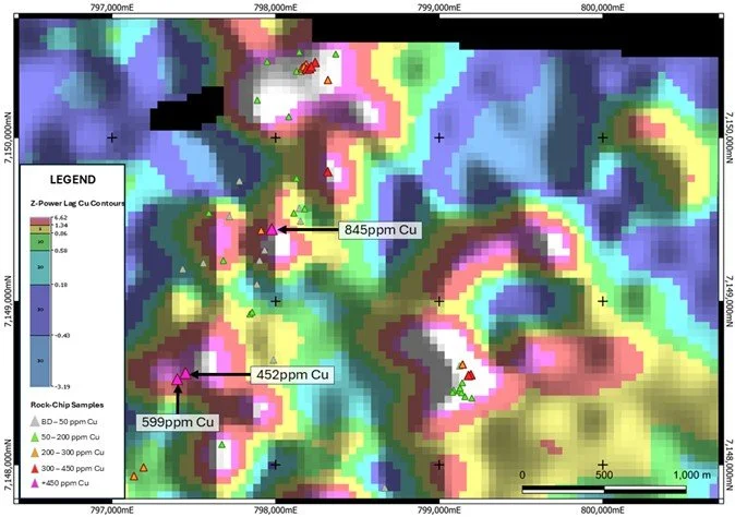
Diorama Z-Power lag sample copper contours, overlaid with rock-chip sample copper results.
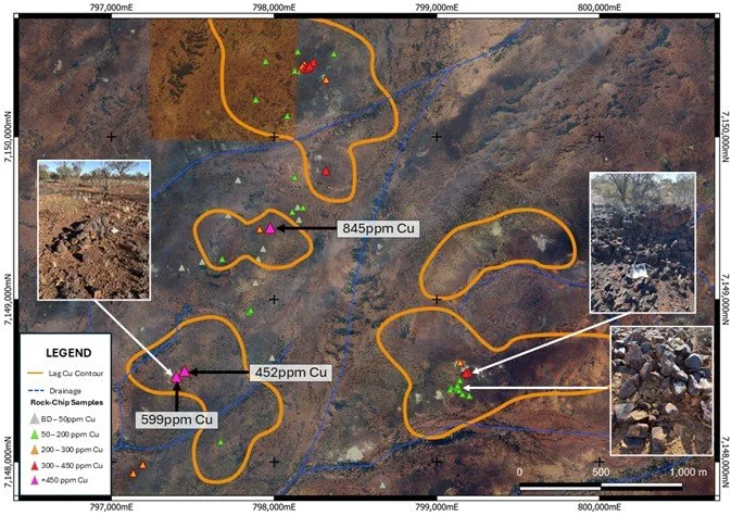
Examples of mapped gossanous quartz mapped at Diorama, showing lag copper anomalies (from Figure above) and drainage. Outcrop is limited, with shallow cover potentially obscuring copper mineralisation.
Great Western interprets Diorama to represent a compelling Volcanic Hosted Massive Sulphide (VHMS) Style mineralisation target, similar to the nearby DeGrussa Copper-Gold Deposit. No drilling has previously been completed at this location.
The Company has designed an air core drilling programme to test below the shallow cover at Diorama, with the aim to advance the target for future targeted drilling of discrete and obscured zones for copper-gold enrichment.
Baroo
The Baroo Target is a previously unmapped quartz vein that has returned elevated copper results (peak result of 1150ppm), close to the Juggernaut Copper-Gold Target. No mapping or sampling of the vein has been previously undertaken and was delineated by Great Western during its regional geological field mapping programmes. A maiden RC drilling programme has been designed to test vein and is planned to be completed concurrently with drilling of the six nearby Juggernaut copper-gold targets.
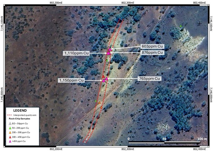
Baroo mapped and interpreted quartz vein, overlaid with anomalous copper rock-chip samples. This quartz vein has not been noted previously before Great Western's latest field work programmes.